Scegli il tuo percorso

Choose your path.


Per poter diventare Eroi di Castelluccio è necessario percorrere la distanza totale di 143 km e 3.800 m di dislivello nell’arco di 24 ore, affrontando le tre salite principali dai tre versanti, le 3 salite per uscire dalla piana di Castelluccio e le 3 salite fino alla sommità del paese. Complessivamente 9 salite e altrettante discese e l’attraversamento del Pian Grande del Pian Piccolo. Il percorso può avere inizio a scelta dei partecipanti da una qualsiasi delle località a fondo valle: Visso, Norcia, Arquata del Tronto, o dal paese di Castelluccio dove sono presenti parcheggi e numerosi servizi di ristorazione realizzati dopo il sisma del 2016. Ciascuno dei 4 percorsi è stato tracciato con una logica di percorrenza (la salita più dura si affronta per prima) che deve essere rispettata per ottenere il brevetto. Per non fare errori è bene seguire la traccia gpx o il road book forniti all’atto dell’iscrizione.

In order to become heroes of Castelluccio it is necessary to travel the total distance of 143 km e 3.800 m in altitude within 24 hours, tackling the three main climbs from the three sides, the 3 go up to exit the plain of Castelluccio and the 3 climbs to the top of the village. Altogether 9 climbs and as many descents and the crossing of the Pian Grande of Pian Piccolo. The route can start at the participants' choice from any of the locations at the bottom of the valley:Visso, Norcia, Arquata del Tronto, or from the town of Castelluccio where there are parking lots and numerous catering services after the 2016 earthquake. Each of the 4 routes has been traced with a travel logic (the toughest climb is tackled first) which must be respected to obtain the patent. In order not to make mistakes, it is good to follow the gpx track or the road book provided when registering.

Percorso A - Partenza e arrivo Castelluccio

Percorso A con partenza a arrivo da Castelluccio

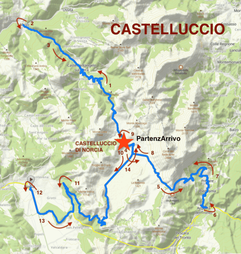
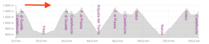
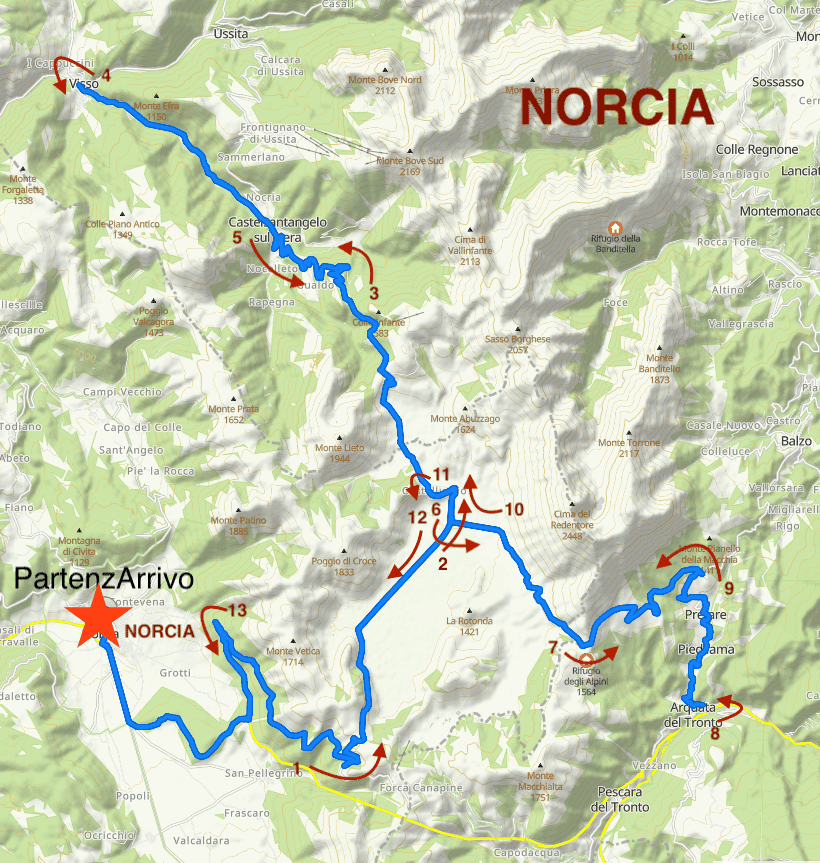
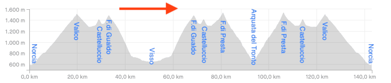
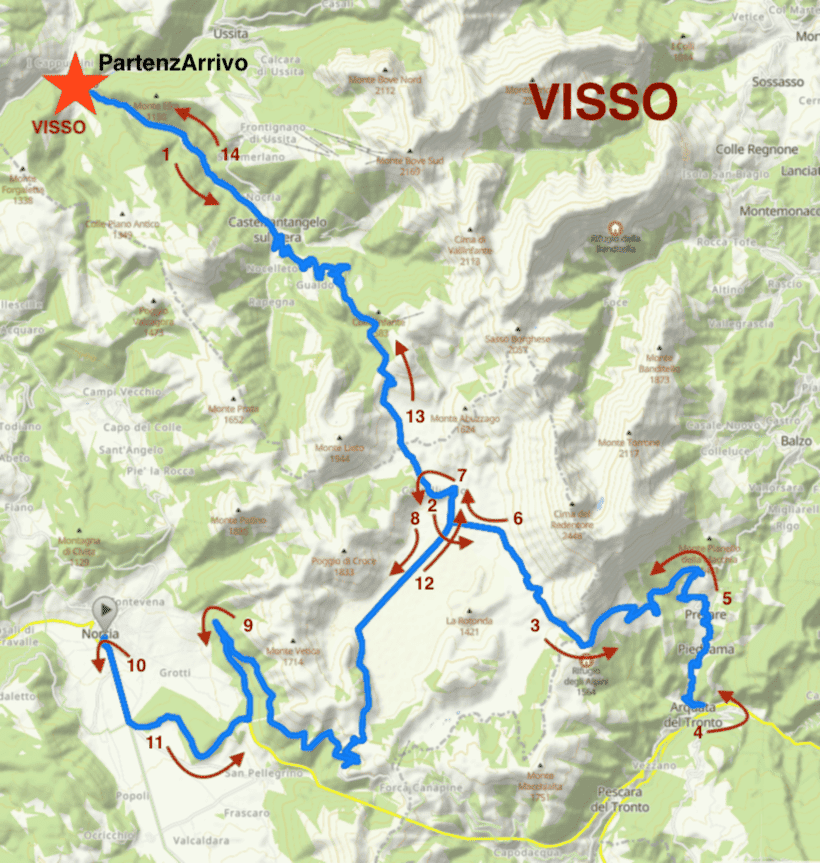
E' il percorso consigliato a tutti coloro che vogliono affrontare la sfida coinvolgendo degli accompagnatori. A Castelluccio sono presenti molti bar, ristoranti e negozi di prodotti tipici ed è possibile fare escursioni a piedi, a cavallo e sperimentare l'ebrezza del parapendio. In bici è possibile affrontare la mini sfida di Castelluccio degli Eroi SMALL (39 km e 860 m. di dislivello) altrettanto affascinante per poter scoprire il Piccolo Tibet. Questo percorso consente di affrontare la salita di Visso, più corta ma più impegnativa per le pendenze a due cifre. Si affronta poi la salita di Arquata del Tronto, più lunga, anch'essa impegnativa, ma con pendenze più costanti, per finire poi con la salita di Norcia, la più lunga ma anche quella più pedalabile. La partenza da Castelluccio è consigliata anche a coloro che intendono affrontare la sfida nei mesi estivi nelle ore notturne.

It is the recommended route for all those who want to face the challenge by involving carers. In Castelluccio there are many bars, restaurants and shops of typical products and it is possible to go hiking, horseback riding and experience the thrill of paragliding. By bike it is possible to face the mini challenge of Castelluccio degli Eroi SMALL (39 km and 860 m in altitude) just as fascinating to be able to discover Little Tibet. This route allows you to tackle the climb of Visso, shorter but more demanding due to the two-digit slopes. We then tackle the longer ascent of Arquata del Tronto, also demanding, but with more constant slopes, ending with the climb of Norcia, the longest but also the most pedaled. The departure from Castelluccio is also recommended for those who intend to face the challenge in the summer months at night.

Altimetria A con partenza a arrivo da Castelluccio

Percorso B - Partenza e arrivo Norcia

Percorso B con partenza a arrivo da Norcia

E' il percorso consigliato a coloro che intendono affrontare la sfida dal versante meno impegnativo per le pendenze in quanto la prima salita, sebbene sia la più lunga, è anche quella più pedalabile. Arrivati a Castelluccio, si prosegue per Visso affrontando poi, al ritorno, la salita più impegnativa. Si prosegue poi verso Arquata del Tronto per affrontare la salita che ci riporta a forca di Presta per poi attraversare di nuovo il Pian Grande, affrontare l'ultima salita e scendere a Norcia. Norcia è il centro più grande del comprensorio e, nonostante il centro storico sia in fase di ricostruzione dopo il sisma del 2016, ci sono molte attività commerciali e il territorio si presta ad escursioni a piedi e in bicicletta. Consigliato per chi viene da Roma, Terni, Perugia.

It is the recommended route for those who intend to face the challenge from the less demanding slope due to the fact that the first climb, although it is the longest, it is also the most pedalable. Once in Castelluccio, continue to Visso, then tackling the most demanding climb on the way back. We then continue towards Arquata del Tronto to face the climb that brings us back to Presta Fork and then cross the Pian Grande again, face the last climb and get off at Norcia. Norcia is the largest center of the area and, despite the historical center being rebuilt after the 2016 earthquake, there are many commercial activities and the area lends itself to hiking and cycling. Recommended for those coming from Rome, Terni, Perugia.

Altimetria B con partenza a arrivo da Castelluccio

Percorso C - Partenza e arrivo Visso

Percorso C con partenza a arrivo da Norcia

E' il percorso consigliato a chi vuole affrontare subito la salita più dura per via di alcuni tratti con un dislivello a due cifre. Arrivati la prima volta a castelluccio si prosegue in direzione Arquata del Tronto per poi risalire fino a Forca di Presta, passare nuovamente per Castelluccio e poi dirigersi verso Norcia per concludere la sfida affrontando la lunga salita, pedalabile, che riporta fino al Pian Grande e, di nuovo a Castelluccio. Superata Forca di Gualdo, si scende fino a Visso dove si conclude la sfida. Visso è un bellissimo centro proprio all'inizio della Valnerina. Purtroppo il recente sisma ha reso inagibile il centro storico e le attività commerciali sono state spostate presso il nuovo villaggio temporaneo. Consigliato per chi viene da Macerata.

It is the recommended route for those who want to tackle the toughest climb right away due to some sections with a two-digit difference in height. Arrived the first time in Castelluccio, continue in the direction of Arquata del Tronto and then go up to Forca di Presta, go again to Castelluccio and then head towards Norcia to end the challenge by tackling the long climb, pedaled, which leads back to Pian Grande and, again to Castelluccio. After passing Forca di Gualdo, you go down to Visso where the challenge ends. Visso is a beautiful center right at the beginning of Valnerina. Unfortunately, the recent earthquake has made the historic center and its activities unusable commercial have been moved to the new temporary village. Recommended for those coming from Macerata.

Altimetria C con partenza a arrivo da Visso

Percorso D - Partenza e arrivo Arquata del Tronto

Percorso D con partenza a arrivo da Norcia

E' il percorso consigliato a chi intende affrontare la salita intermedia delle tre. E' tutta pedalabile con le pendenze maggiori alla fine, verso Forca di Presta. Dopo essere passati per la prima volta a Castelluccio, si prosegue verso Forca di Gualdo e poi Visso per affrontare la salita più impegnativa per via delle pendenze. Dopo essere transitati per la seconda volta a Castelluccio, si procede verso Norcia per poi affrontare l'ultima lunga salita pedalabile che ci riporta sul Pian Grande. Dopo il terso passaggio a Castelluccio, si affronta l'ultima breve salita fino a Forca di Presta, per far ritorno ad Arquata del Tronto. Purtroppo il centro storico di Arquata è inagibile e i pochi esercizi commerciali sono presso il nuovo villaggio temporaneo. Consigliato per chi viene da Ascoli Piceno e da Rieti.

It is the recommended route for those who want to tackle the toughest climb right away due to some sections with a two-digit difference in height. Arrived the first time in Castelluccio, continue in the direction of Arquata del Tronto and then go up to Forca di Presta, go again to Castelluccio and then head towards Norcia to end the challenge by tackling the long climb, pedaled, which leads back to Pian Grande and, again to Castelluccio. After passing Forca di Gualdo, you go down to Visso where the challenge ends. Visso is a beautiful center right at the beginning of Valnerina. Unfortunately, the recent earthquake has made the historic center and its activities unusable commercial have been moved to the new temporary village. Recommended for those coming from Macerata.

Altimetria D con partenza a arrivo da Arquata del Tronto

Specifiche

Specs

143 Km
3.800 metri di dislivello
9 salite
Altezza massima 1.530 metri
Altezza minima 590 metri

Punti di ristoro lungo il percorso

Refreshment points (eateries)

  • Castelluccio di Norcia (Bar, Ristoranti, Alimentari)
  • Castelsantangelo sul Nera (Bar, Ristoranti, Alimentari)
  • Visso (Bar, Ristoranti, Alimentari)
  • Piedilama (Bar)
  • Arquata del Tronto (Bar)
  • Norcia (Bar, Ristoranti, Alimentari)